Friday 11 September 2015

Day 136: Crossing into CANADA!!!

Mileage: 12 miles (2575.4-2587.5)


After a restless sleep, I woke up a bit before 7am. Malarky took off shortly before I did, and I left before Commando. It was good to finish alone: to collect my final thoughts and say goodbye to the trail. I realized the magic of the trail was fading, that by the time you get to saying farewell, the best part was already gone. Just seven more miles to the border and in that moment, they couldn't come too soon. I took a picture of my final camp and the lake and moved on without too much ceremony.


I was anxious. Very anxious. Yet beauty still surrounded me as I pressed closer and closer to my five-month goal. I reached Goat Haunt Ranger station and the head of Waterton Lake. I could literally see Canada just a few miles away. It was still too early for the ranger to be at his post, so I just walked by the buildings, which seemed out of place in the wilderness of the night before. I reflected on my hike, but mostly just thought about being finished walking. I was ready to be done.


Gentle hills rose and dropped as the trail meandered along the lake. The sun was bright and the sky was blue as the day before. Somehow, I was finishing on a nice day, which was really the last thing I expected after so many days of sleet, rain, bitter cold, and snow. I saw some big piles of bear scat and wondered if I'd really make it through some of the densest bear country in the Continental US without seeing a Grizz.


And then I saw it: not a bear, but a dock with a person on it and a clearing just around the next bend. It had to be the monument. As I got closer, I realized there were actually two monuments, miniature obelisks marking the official US-Canadian border along the 49th parallel. A swath of trees was cleared along the entire border, making you wonder if there was a yellow line on the bottom of Waterton Lake as it crossed.


I was silent as I approached the marker, not screaming or jumping for joy as this isn't what I felt like doing. I just collapsed on the obelisk, hugging it in relief. I couldn't believe it had been nearly five months since I'd started. Mexico and April felt so far away. I was so naive and anxious back then. Now, I just felt tired and ready to sleep. Ready to lounge. Ready to do nothing.


After a few minutes of silence with the monuments, I walked down to the dock and told Malarky congrats. He'd finished his Triple Crown, completing the Pacific Crest, Appalachian, and now the Continental Divide Trail. It was quite a feat, which only a few hundred others had ever done. He was perhaps the first from Northern Ireland.


It was a warm morning in the sun and I decided to jump in the lake. I figured there wasn't a better way to feel really alive and take my first bath in Canada. Malarky took a picture for me and I quickly swam back to the dock after plunging in the icy water. We waited for Commando as I dried in the sun. The lake was freezing, but the air was mild and I didn't shiver. Kasey's dad showed up first with a CDT t-shirt and two beers for me and Malarky. 


Then Commando wandered up, followed shortly by my mom with my dog Cooper. I was proud that my mom had made the four mile trek, as I was a bit worried about her and my dog. I saw she had brought bear spray, and I was glad after I saw how much bear scat I'd seen in the last few hours.


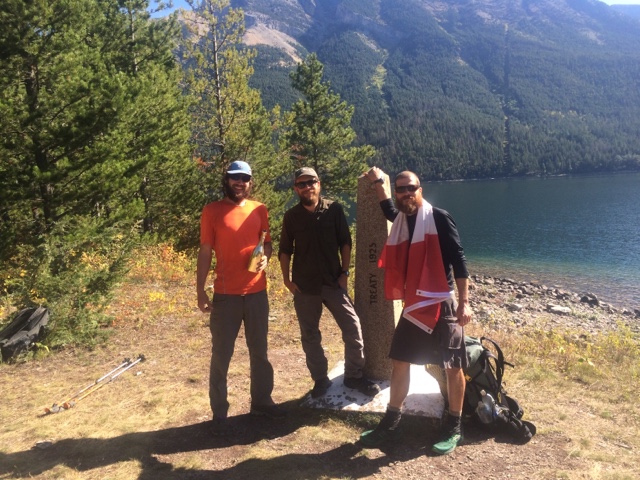
We posed for all kids of photos at the monument, finished our beers, and swigs of Champagne that Commando had requested. Malarky left first and we followed shortly thereafter. Though we were done, we still had a long four-mile walk to the car. My mom was moving slow and Commando took his Dad's pack. I had Cooper strapped to my waist and he tugged and pulled anxious to chase after every smell. I couldn't let him off though, as I was sure he would try to play with a bear or whatever else he found.


When we finally reached the trailhead my om didn't know where she parked. That was pretty routine, but we eventually found it. We got food at a bar, including some Poutine, Quebec's gut busting combination of fries, covered in gravy and cheese curds, along with some beers. Laura had surprised me by scheduling a massage. My muscles were a bit tender, but it still felt nice.
Notice the border line, clearcut of trees, across Waterton Lake

My mom and I took a look at the Prince of Wales hotel, a historic lodging overlooking Waterton Lak and then went to the Super 8 north of town. 


I looked at book about the Great Divide Trail, which continued from the Canadian border 800 miles to the north of Jasper. Maybe it would be my next adventure. It really hadn't sunk in yet that I finished and I wasn't sure it would for a long time. That night I slept with my dog Cooper by my side and dreampt of worlds to come.

Me, mom, and Cooper. She drove all the way from Nebraska!

Thursday 10 September 2015

Day 135: Sunny Day over Swiftcurrent Pass to Kootenai Lakes

Mileage: 30.2 miles (2545.2-2575.4)


Wow, talk about an incredible last full day on the CDT! Malarky and I started it off with breakfast and coffee from the convenience store. We talked about the crazy lady from the night before and it turned out all the staff and even other guests knew about her and supported our suspicions. Apparently, a ranger had escorted her out of the store a few days previous for stealing. Anyways, we got started by eight and were greeted with our first bluebird day in the park. So blue I couldn't help but feel optimistic about the future, regardless of what it may bring.


Swiftcurrent Pass was laden with incredible towering peaks, striated in different ways, almost as if a fine comb had been dragged through the rock in one direction before it had hardened. I have a suspicion glaciers formed many of the grooves by grinding against the rock, but will have to look it up when I get back to civilization. I trailed Commando and Malarky up the valley, admiring the crystal-clear lakes which reflected the peaks above like slowly undulating glass and was rewarded by seeing some Mule deer in the stream before the climb up the pass. The trail traversed the cliff after penetrating deep into the long glacial valley, passing two glassy lakes before the ascent.


As I climbed, I scanned the valley below for Grizzlies, convinced I was going to see one or a few wandering around the dense Alder thickets near the fast-flowing stream.  Scanning the valley, it was amazing to see how quickly all the snow had melted, even up high. There were only a few small and avoidable patches way up high. Again, were right on side of cliff but it was marvelous trail.


Malarky and I took a break on top of the pass and heard some strange roaring noises emanating from above. Neither of us had ever heard a simliar sound, yet were totally baffled - it could have been anything from an Elk to a Grizzly - we had no idea. Heading down the pass, we strolled into Granite Peak Chalet, which was built in the early 1900's by the Great Northern Railway company. It was owned by railroad until early '50s and then handed over to Park Service. It's been managed by same family for four generations and you can tell by it's backwoods feel and staff who are friendly because they want to be, not because it's company policy. They even gave us free Peanut M&Ms for being a thru-hiker, woohoo! It was pretty steep to stay, but a really cool place to hang out. I was reminded of the Moosilauke Ravine Lodge, where I'd worked after College. It had the same sweet smell of damp wood and mildew and matched the cozy feel, stocked with board games, snacks, and hot beverages.


I could have sat by the fire all day, but we needed to push on. We joined the Highline Trail a little ways back from the Chalet. We looked towards the south where it climbed over a high alpine pass, but we were headed north. We traversed the cliffs for ten miles to Fifty Mountain with water flowing everywhere and giant piles of Grizzly scat littering the trail. They were eating bright orange berrries that they seemed unable to properly digest - I guessed it was sumac, but it was hard to say for sure. Hoary Marmots scampered up and down rocks, warning one another of our presence. The brush was dense on each side of the trail and we were just waiting for a Grizz to clamber out, mouth bright orange from gorging on the mystery berries.


It was really fantastic trail looking across each valley, going up and down and up and down. Heavens Peak glistened to the south and others followed the west and north. The snowfields shimmered atop impossibly steep peaks, making me wonder how the snow hadn't fallen off to the broad valleys below. The last remnants of glaciers clung to the north side of the 9,000' peaks. Most would be gone within the decade.


We had one final climb to Fifty mountain and then down almost 3,000' to the Waterton Valley, which we'd follow to Waterton lake and Canada. It was not only the final climb of the day, but the final climb of the trail. It's weird to be typing that. We'll just say we had a little extra motivation.


We camped at Kootenai Lake just seven miles from the border. I used all my power not to continue walking and save the border for tomorrow to meet my mom and dog as we planned. Tonight is my last night camping and I should savor it. But I couldn't help feeling anxious - I was ready to finish, but what would come next? I was so used to just following the trail - in some ways it was easier to be following a path, to have a destination. Tomorrow, ironically, I would be lost. There wouldn't be a goal - I'd made it to where I was going. What was next? Transitions are the hardest part.


The lake reflected the mountain and clouds above like glass. I thought more about what was next and tried to sleep. Mysterious sounds resonated from across the dark water of the lake. They were hollow echoes that you only hear in the woods, alone in a tent. Mysteries of the night, never to be solved, but which caused endless wonder. The crack of a breaking branch, the clash through the trees, the howl and blood-curdling scream. Above all else, I would miss these little mysteries and the dark shadow of the unknown.


Wednesday 9 September 2015

Day 134: Piegan Pass and the Chalet

Mileage: 16.5 miles (2528.7-2545.2)


I had breakfast with my mom and the whole crew - the last time we'd all be together, but it was mostly the normal shenanigans. After pancakes, we said goodbye, and my mom gave me, Commando, and Malarky a ride up to the CDT where we'd finished the roadwalk. Our first test was up Piegan Pass, above 7,000 ft. It was slushy snow but really not bad compared to what we'd done the days previous. We ran into quite a few day hikers on the way up, passing them all at our blistering pace, leaving them wondering what the heck we were doing. I was a bit behind Malarky, and one guy said, "Are you with the guy ahead? Good luck catching him - he's running up the mountain!" I smiled and said, 'thanks' not even pausing for a breath.


On top of Piegan Pass, reached by a narrow trail once again clinging to the cliff, I spotted a family of Hoary Marmots, my first sighting of this species of portly high-mountain dwellers. At first, I mistook them for a group of coyotes or even thought one might be a wolverine, before I saw how chunky they were. They were bigger than their yellow-bellied cousins, but once I saw the whole group, there was little doubt they were Marmot kin. It was clearing a bit as we got higher but still a high ceiling, veiling the saw-toothed summits high above.


The way down wasn't bad either, again nothing like the days previous which were dangerous in spots of icy rock and deep snow. We admired the sheer black cliffs and the top of craggy divide, still shrouded in a cloud of mystery.  We saw lots of black bear prints on our way down to Josephine Lake and daring Mountain goats in a precarious spot on the cliffs above. Incredible waterfalls shotdown hundreds of feet from precipitous cliffs, hitting rocks and permanent snowfields below.


The rock had bands of red and green on a background of slate grey. The clouds lifted higher and higher but never fully burned off as the day went on.

It got greener and greener as we headed down the valley until we finally hit Swiftcurrent Lake and saw the Many Glacier Hotel. The lakes were enormous and different shades of green, turqouise, and blue, depending on where you looked. We finally reached the Ranger Station and got our permits for the next two days. We'd stay at Kootenai Lakes tomorrow and then reach Canada the next day. We were so close and have been promised a sunny day tomorrow. Tonight we have to stay in the front country campground though.


Unfortunately, the night didn't end here. An older lady with white hair standing straight up like Einstein was also staying at the walk-in site and turned out to be totally insane. She talked to herself most of the night in front of the campfire, murmuring some things too vulgar to repeat, but included using the N-word, calling George Bush a "white n-word", murmuring "kill all the children", and endlessly talking about Jackie Onassis and JFK. In between each rant and rave she'd hawk a giant lougie, almost sounding like she was loosing a bit of her lung with each hack.


Malarkey moved his tent in the middle of the night after she'd come up to his tent and said, "Commit suicide." She was by far the craziest person I'd ever met. And on top of that, horribly vulgar and racist. I didn't sleep until past midnight. I was ready to bear spray her if she got within five feet of my tent. So much for a restful night in the front country.


Tuesday 8 September 2015

Day 133: To St. Mary and Slackpackin' back

Mileage: 24.5 miles (2499.2-2528.7)


I slept in a bit and kept the other two waiting this morning. My legs felt pretty tight and sore after the long day before. We saw quite a bit of Moose tracks and scat up and down the undulating green wooded hills. I was following Malarky when he suddenly stopped and pointed at a big brown figure in the distance. It was a Moose walking down the trail. He galloped off quickly after he spotted us, allowing us to continue. After what seemed like more than two miles we came down past the head of Red Eagle Lake where I was happy to find a pit toilet. We continued down the path until we finally started seeing day hikers, which signaled we were close. Day hikers were always a good sign. The clouds had subsided some but many of the tops of peaks were still clouded over.


We got to the trailhead and walked to the road, following St Mary Lake, and met my mom in town. We ate lunch in Park Cafe and then decided to get a room. Me, my mom, and our dog shared a room at the Red Eagle and had Malarky and Commando next door.


Commando and I got dropped by mom at the intersection of the CDT with the Going to the Sun road, since the official trail was closed. We figured we'd get the road walk out of the way, so we'd could just start fresh on trail tomorrow. We had pretty awesome views of the lower peaks along the lake before it clouded over when we got out of the car. It wasn't until driving up it that we realized how enormous St Mary lake was and that we'd have to walk along it for ten miles. A sign told us the lake was 299 ft deep, and I wondered if Lake Trout or other monsters lurked its depths.


The drizzle began spitting at us as we started our slackpack. We'd left our packs in the room and walked toward town, making it easier on ourselves and my mom, who'd only have to come get us at the road we'd walk in on, instead at the top. It was cold and windy, but at least the wind was at our backs.


 At this point we were set in keeping our continuous footpath from Mexico to Canada. Since we'd already come this far there was no reason to skip now, even if it was a dangerous roadwalk along a busy two-lane road without a shoulder. It was unfortunate because the trail we were supposed to be on was closed due to fire damage, though upon further inspection it really didn't look bad. We finished the walk by 5pm and my mom just happened to be there right as we rounded the corner to the visitor center.

My mom after she dropped us off at the Going to the Sun Road to hike down

After we cleaned up, we headed down to dinner and saw Sanjay, Tom, and Rafiki trying to hitch. We stopped and convinced them to just stay in St Mary and eat pizza with us. It was fun reconnecting with them and we shared stories from the last few days. We both had been through quite a bit of snow and had plenty to share. It was fun to see the guys one more time. After dinner we headed back to the hotel and headed for early bed.


Monday 7 September 2015

Day 132: From Two Medicine and over Triple Divide Pass

Mileage: 29.5 miles (2469.7-2499.2)


We started hitching after deep fried huckleberry French toast at the diner. It took awhile but at least it was a blue sky day. We'd met our buddy Malarky from Northern Ireland the night before and he was heading out with me and Commando. We had decided to take an alternate route up Dawson Pass, which was supposed to be prettier. Unfortunately, by the time we got up there the blue sky had been conquered by the legions of clouds. And there was snow at 6,400', far below where we'd top out more than 1,000' higher.


We found sketch, deep steep snow and ice around Mt Morgan with bitter, strong winds howling in our faces. And we were seeing grizzly prints everywhere in snow. It felt like we were back in the San Juan's except now there were Grizzlies and I wasn't nearly as mentally prepared. The trail itself was only 18" wide in most places, so the snow covered it completely, making it not only nearly impossible to follow, but also quite treacherous.


Steep snow chutes funneled down to sheer cliffs hundreds of feet below and none of us had an ice axe or crampons. We took turns breaking trail, frequently stopping to warm our freezing hands. After a particularly scary section where I was breaking trail waist-deep in snow, we finally reached Pitakamin Pass and joined back with the CDT. We saw other parties headed up the way we came and were slightly annoyed that they were taking advantage of the trail we broke in all their winter gear, especially since they were day hikers, returning to somewhere dry and warm this evening.


We headed down and down from Pitakamin, and it felt like very long time before the snow finally disappeared. We took our first break of the day at snowline and all of our bodies ached after having a few days off and then pushing so hard.


Below the snow line, everything turned green and water rushed everywhere, down waterfalls, and through creeks, and bubbling up from underground springs. It was warm and pleasant, almost like the morning was just a horrible nightmare, back in the San Juan's in southern Colorado.


We ran into some day hikers before Triple Divide Pass, who had broken at least some of the way up to 7,500 ft. As we ascended the wind picked up but at least we were following tracks uphill, instead of breaking like earlier in the day. The trail clung to the side of the cliff as we looked down on the sprawling Grizzly Medicine Lake in the deep glacial valley below. Thin, braided waterfalls tumbled down the sheer cliffs across the valley and on top of the trail.


The clouds began to lift as we neared the pass and we ended up with some spectacular views from Triple Divide Peak, whose summit sent waters east to the Atlantic, west to the Pacific, and north to the Hudson Bay. We traced the rocky spine of the naked divide as it made it's way north, thankful we weren't tasked to walk on top of it sheer, icy backbone.


The cliffs were textured with a dusting of snow, revealing every contour and bend in the bands of granite. On our way down the north side there were no more tracks and the way was steep and full of snow. Though nothing as bad as traverse around Mt. Morgan earlier in the day, wading through hip deep snow.


Again, it took longer than it should have to get out of snow from Triple Divide, but we couldn't find a campsite anywhere - and our designated one was still miles away.  We hiked on in the dark, making noise as we went, to scare off any curious Grizzlies. Around nine, well after the sun had melted below the horizon, I saw a small flat-topped hill and suggested we camp there. We'd seen a lot of bear sign that day and I didn't want to run into any grizzlies at night. We setup camp in utter exhaustion and were in bed by 9:30.


Sunday 6 September 2015

Day 129, 130, and 131: Triple Zero in Kalispell

Mileage: Zero


Me and Commando got a hitch with a nice lady who took us to Columbia Falls outside Kalispell. After we crossed the divide at Mariah's Pass all of a sudden the barren landscape transformed into lush, deep green forest more remiscent of the Pacific Northwest than the barren plains we'd left behind. Towering spruce and fir trees dominated the landscape as the rains fell more generously on the western slope than from where we'd come.

Michael, my friend Cody's dad, picked us up at the coffee shop in Columbia Falls and took us back to their house a bit south. It was a beautiful house on about 20 acres of property, complete with a pond and horse pasture. Michael is in his sixties and one of those guys that can talk forever about one story or another - whether it's about hunting or traveling with his wife or kids, he always had an anecdote ready, and I was happy to listen. 

When we arrived he immediately offered beers and I ended up drinking plenty of beer with him and Casey over the weekend. He showed us his African animal collection on the wall complete with Oryx, Black Bear, and Deer. 

We went out and fed the fish in the pond, trying to scare off the osprey which was stealing his trout. The western slope of the Bob Marshall Wilderness lay to our east and we knew all this rain would open it back up. As it cleared up we saw the tops of the nearest peaks were all licked with snow. We laid around and ate a lot. I texted my buddy Cody telling him how good of cook his mom is and he responded: "She'll try and make you fat" Our breakfasts were awesome, including eggs, toast, and bacon and then fresh-baked banana bread the next day.


I watched the first Husker game and though they lost a heart breaker I was proud of how they played. Afterwards I played bumper pool with Michael as Casey had gone to hang out with another friend. We drank more beer and hot chocolate with schnapps. I fell asleep early that night, sinking into the soft bed.


The next day we went to a muscle car show and Karen and
Michael's friends came from Oregon. Good appeared out of nowhere and we all feasted for lunch. 


My mom came and picked me up with her friends Rebecca and Yes and our dog Cooper! We all drove to East Glacier and we had a nice dinner at Luna's. It was great to see my mom and dog, though it almost didn't feel real. I planned to meet my mom at St Mary's on Tuesday and I shared a room with Commando at Brownie's. His planning ahead was good and we both slept well.

Rebecca, Yes, and my mom in the back, me and Commando up front - a tight squeeze!


Sharing hot chocolate with mom.