Thursday 30 April 2015

Day 19: Malpais and Chain of Craters

Mileage: 30.1 miles (351.1-380.2)

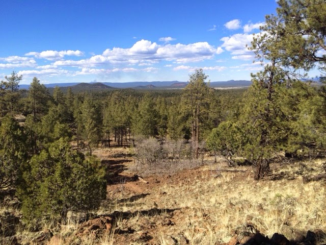
Even though it's called the Continental Divide Trail it's actually rare the official route is right on top of the divide. Today, however, was an exception ... meaning a lot of ups and downs to stay on top of the ridges! 


I started out the day on about 3/4 mile of lava rock, which was really cool, despite the difficult walking! That particular lava rock is about 1,000 years old, which is quite young for Malpais as the oldest in the park is 100,000 years old. What that means is it hasn't had a ton of time to weather so it's still very sharp and loose ... not a good combo for hiking!


It was a short section though and quickly made my way West towards the divide and the craters which were created by ancient volcanoes. Many of the peaks are the cinder cones from these volcanoes, now densely forested because the debris from the eruptions were nutrient-rich and created great soil for the various pine, juniper, and aspen trees, as well as great habitat for species like Elk, Pronghorn, Bear, and many other creatures.


I actually saw quite a few Elk, some of whom had taken to grazing amongst the cows, which I thought was hilarious imagining them side-by-side having lunch. 

I'd realized the day before that I needed to make big miles to get to Grants by Saturday before the post office closed at noon ... don't ask me how I get myself in these situations, but I just hate letting the postal service set my schedule so I needed three thirty-mile days in a row to make that possible.


So, it was hiking from sunset to sundown, luckily finding some unexpected water along the way to make things a bit easier. The water report still hadn't been updated for this year so I was kind of the test dummy! One of the trail angels (people who help out hikers) up in Grants told me it was a little dicey to take the route I chose, but I figured with the wet spring I'd be ok. 


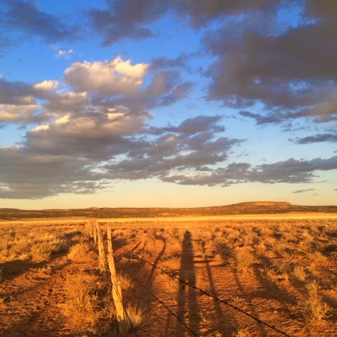
Cowboy camped again tonight under stars next to a pond that doesn't seen to exist anymore ... only nine more miles to the ranger station and clean water though!


Wednesday 29 April 2015

Day 18: North towards Malpais

Mileage: 31.2 miles (319.9-351.1)

I got an early start after saying goodbye to Problem Bear and Natty. I had to carry a good amount of water because the first available wouldn't be for another 16 miles. Again, I'd be on dirt roads most of the day, which was definitely starting to get old!


It was a pretty clear day and the sun was strong. I had packed out a mini pecan pie from town and couldn't resist eating the whole thing on my first rest break. It was wonderful, just loaded with pecans, though the crust was a tad dry and lacked the real buttery goodness (I bake, okay?). I reached the water source, Thomas Mountain Ranch, by 1pm and was greeted by Anzie and John Thomas, who had to be the cutest couple I've met on the CDT. 


They've been married since Anzie was fourteen (she lied about her age) and now it's been well over 60 years. After seeing so many 'No Trespassing' signs it was wonderful to see a couple of ranchers who were so welcoming to hikers and willing to share their water and good humor. 


Anzie gave me a tour of their sheet metal house which resembled one of those big hangars for combines and other farm equipment you see back in Nebraska. The house was complete with a late 19th century stove, more kitchen aides than I've ever seen, and a giant American flag Anzie bought right after 9/11. She apparently beat four others to the flag at a thrift shop right after the plane hit the first tower. Fox News blared in the background about same sex marriage and I knew I should probably keep my views to myself.


After snapping a photo I headed out back on the trail, sad I couldn't stay longer. I was doing an amalgam of the alternate and official CDT route because I did want to see Malpais (an area with significant volcanic activity in the past), but I didn't want to do the 50 mile paved road walk to get there. 


So, I did about 27 miles on back roads (the Cebolla Wilderness Alternate) and then went cross-country three miles northwest to hit the Chain of Craters Trail (official CDT) which would take me into Malpais. I may have crossed a few miles of private land but otherwise I would have had nearly six more miles on road. I sang Woody Guthrie "This Land is Your Land" the whole way, emphasizing the 'my' part.


I stirred up quite a few Pronghorn Antelope, which are really fascinating creatures. They can run up to 70 miles per hour and can see objects (eg predators) more than six miles away. I never got close enough for a photo but I know it was them because they were quite small and had big bushy white fur on their bottoms.


I made it to Chain of Craters just as the sun was setting. I was too tired to setup my tent so I just decided to cowboy camp (definition: camp under the stars). It's the first time I've done it on the CDT so let's hope it doesn't rain!

Tuesday 28 April 2015

Day 17: Zero in Pie Town

Mileage: zero!

I slept in until 7am after a very restful slumber to find the smell of coffee brewing downstairs. I grabbed a cup and plopped down into the chair next to the fireplace thinking about what I'd do with my day off. I decided that I definitely needed to do laundry and eat pie. If anything else happened that'd be great. I talked with the other hikers and we planned to get breakfast with Nita (owner of the house) and do the tour of town at 10am. 


Before that I washed my laundry by hand, washing and rinsing my clothes five time before the water didn't turn black when I kneaded the clothes back and forth ...
it was still light brown by the end, but I didn't want to waste water. I hung them up to dry and we set off for breakfast after a group photo. Notice the toasters in the background ... I was actually worried the night before how I'd find it ... silly me!


Before breakfast we took the tour of town, the highlights of which included the windmill museum (which also sold pie ... I got pecan), and also one of the antennae for the Very Long Baseline Array, a National Science Foundation initiative which allows scientists to study distant galaxies and stars. The high resolution images they get from this array could spot a football on the moon!


After that we had breakfast which really is a subjective term for hikers. For instance, I had pancakes, grilled
cheese, French fries, and coffee. Afterwards, I realized from the butter wrappers that I must have used seven or eight of them myself ... oops! My mother would have been horrified by the lack of real maple syrup, but I didn't mind the corn sugar. And who am I kidding, my mom would have brought her own anyways (seriously, she does this anytime she goes out for breakfast).
After breakfast I said farewell to the other hikers who were hiking out and stayed at the cafe to take care if some internet business. Later in the day, while I was on the phone with my dad, my old friend Natty showed up, after having hiked 25 miles that day! I showed him around the house, made each of us a pizza, and we each had a beer. So good.

Later in the evening, a little after 8pm, another hiker, Problem Bear, showed up while I was peeing outside. He looked pretty out of it and said he'd just hiked close to 30 miles that day, so I gave him the royal treatment as well, fixing him up a pizza and sharing the rest of my second dinner with him. I also got a fire going in the the stove to make it real cozy! I had wanted to read all day, but by the time I sat in front of the fire, I could only read a few pages before I was exhausted. 

I went to sleep happy I could return the favor to other hikers as the others did for me the night before. I sure will miss Pie Town!

Monday 27 April 2015

Day 16: A long haul to Pie Town

Mileage: 34.5 miles (285.4-319.9)

I woke up resolved to make it to Pie Town the same day. Unfortunately, it had snowed and rained most of the night so it took awhile to break camp. By 6:45 I was walking, with a long day ahead. After a few miles of ups and downs, I began the ascent of Mangus Mountain, a 9,600 ft peak with a fire lookout on top. I was on dirt roads all the way to Pie Town, which was a blessing as long as they weren't too muddy to walk on. It sure beat hopping over dead trees and trying to find the trail every five minutes.


As I climbed Mangus the snow became more prevalent on the trees, eventually covering the road completely. My footprints melded with that of the coyotes, rabbit, elk, and other creatures who used the same trail hours or even minutes before. I rustled about ten elk from their breakfast, all does perturbed by the disturbance. By 10:30, I'd made it to the top of Mangus but didn't see a trail to the fire tower and summit.
Right as I pulled out my GPS a jeep pulled up behind me. The guy slowed down and told me he was the lookout and I should come up to have a look around. I'm sure glad he pulled up, because it was really fascinating learning about the system of towers and how they locate fires using triangulation and a specialized instrument that was like a enormous compass fixed in place.


 He also showed me a bunch of picture of lookouts from the '20s and what it was like in the old days. Turns out they used to just build platforms on top of Ponderosa pines or other tall trees. 


Sad to leave so soon because of the great conversation (and the gas heater), I said goodbye to the lookout and he gave me a smokey the bear 'live strong' bracelet, which said 'prevent forest fires.' The lookout thought I was crazy to try to make it the 26 additional miles to Pie Town but I just smiled and said, 'thank you'.

From Mangus it was mostly downhill, with a lot of minor ups and downs along the way. Over the next 26 miles I totally circumnavigated Alegres Mountain, one of the larger peaks around (10,000+ feet), and really formidable looking from it's southern face.


As I got lower the roads dried out, except for patches of mud here and there. I stopped a few times to dry out my socks and clean my feet, but pushed as hard as I could while staying well-fed and hydrated. I knew that would be important to make it the whole 35 miles.


I counted down from twenty miles left, then fifteen and ten and finally five. I'd enter a trance-like state, focusing soley on putting one foot in front of the other. With about ten miles left I noticed the sky was getting very dark off in the distance. The wind started picking up and I braced myself for a storm. I put on my rain jacket, but thankfully only got a few bits of hail, with the storm pushing to the north. I was treated to a beautiful sunset and even a rainbow as I trudged through the final miles. I kept telling myself, 'If you only could make it by 8pm, you won't be hiking in the dark.'


When I finally reached Pie Town, the  final hill felt interminable (...the next day it didn't even look like a hill). I walked into the Toaster House at 8:12pm, greeted by three hikers I'd met previously - Reckless, Maniac, and Karma. They were all pretty surprised to see me so soon, but treated me like family - they cooked me dinner of eggs, pizza, and beer and had a fire stoked in the stove.
The owner of the house, Nita, even came by later and we all had a singalong by the fire. How things change on the CDT: from one night feeling totally alone and wet and cold, to the next totally dry and warm with a full stomach, feeling like I was with family. That's the magic of this trail - sometimes you are determined to get somewhere and you're not even sure why, but once you get there you know. You have ups and downs and sometimes you have no idea when they'll come, but there they are.

I somehow mustered the energy to shower around 11pm, then hung out some more and went to bed by midnight - the latest I'd been up since being on the trail - I sure was glad I made it to Pie Town.

Sunday 26 April 2015

Day 15: Wintry mix to and from Reserve

Mileage: 11 miles (274.4-285.4)

We woke up around 6am after it had rained all night. Natty remarked that it almost looked like snow was on the tent because of the semi-transparent material. Turned out it was actually snow, about an inch of it, the slushy kind that is basically just wet slop. We didn't get started hiking until around 7am after both getting ready and shaking off the tents. We only had about 5 miles to the road, from which it was a 28 mile hitch into Reserve, NM, where there was a place to get a hot meal. 


After 8 days without real food, I decided I'd hitch in with Natty and return to the trail later that afternoon. After the two hour slog through mud and freezing rain, it took about 40 mins of thumbing to get a ride. The driver, Dave, was a hydrology student from New Mexico Tech in Soccoro and he was headed West to get water samples from nearby seeps. He had a sweet German Shepard who loved attention once she let her guard down.


Natty and I pigged out in Reserve, having breakfast and lunch within a two-hour period. All told, I had chili-cheese fries, toast, hash browns, a three egg omelet, chips and salsa, two cups of coffee, hot chocolate, a slice of pecan pie, and half an enchilada before I realized I might explode if I ate anymore.


After doing some internet stuff and talking a bit to Laura and my mom, I took the other half of the enchilada to go, said my goodbyes to Natty, and set out to hitch back to the trail. 

I was out on the road for awhile and was getting pretty discouraged, but what did you know, Dave, the driver from earlier pulled up in his silver Honda Civic and picked me up once again. This time with his German Shepard excited to see me. While we drove it started to drizzle a wintry mix and by the time we got back to the trailhead it was full on hail. Though it was luckily just pea-sized, it was pretty discouraging.


I'm not sure if it was missing having a hiking partner like Natty, talking to Laura and my mom, or what, but all of a sudden I felt completely alone. It's funny it took 300 miles, but it just hit me that I was totally alone out there, exceedingly small in such a chaotic universe. I tried to hike off the feeling but my feet kept sinking in a few inches of mud, continually caking itself around my shoes, making them feel like lead weights.

By eight o'clock it was dark and it was full on snowing and I still had to setup my tent. I was freezing and my hands weren't quite working but I managed to set it up and crawl inside. Thankfully, it was pretty dry in there and once I got into my sleeping bag I fell asleep pretty quick. Right before I fell asleep, I told myself I was not sleeping outside the next night. That meant getting the 35 miles to Pie Town in one day.

Saturday 25 April 2015

Day 14: Back on the CDT

Mileage: 24.5 miles (249.9-274.4)

No rain last night, so was able to get some decent sleep. We got an earlier start, hiking by 6:45. As we walked up the dirt road we came upon a few elk drinking at the stream. They were all females and though they ran away they seemed more curious than scared as they paused and peered back at us from up the hill. They are really beautiful creatures, and have huge hooves! I also learned yesterday (...thanks to my Audobon nature app) that male elk have up to 50 females in their harem. I wondered what all the other bull elk do who don't have a harem? You imagine there must be 49 males out there for every one that has a harem, right?? Anyways.


Natty and I had a lot of ups and downs today, with some big climbs up some unnamed peaks. We reached close to 9000 feet and definitely felt the elevation in our breathing. Natty was a champion once again keeping up with me, especially in one section where I was really pushing to reach the next water source (...which turned out to be a cow pond). We did two 24+ mile days in a row, which each were a record for him on the CDT!) 


After one last climb up Wagontongue Peak we sharply descended and had some great views of the Gila National Forest below. We were pretty parched and still had a long way to the next water but luckily found a spring, about a quarter mile off trail. It was just a pipe sticking out of a rock with a very slow trickle so it took us about 25 mins to fill two liters of water. After that we setup camp, talking about different routes we might take and all the food well eat in town.


I might hitch in to Reserve tomorrow with Natty so I can get some hot food. We realized the only restaurant in Pie Town (the Pie-o-neer cafe) will be closed when I arrive Tuesday and I really want a hot meal. It's a shame because the pie is world famous. I might call tomorrow and see if they'll deliver to the place I'm staying in advance. Anyways, raining again tonight so Natty in with me one last time. Hopefully it won't rain too hard...

Friday 24 April 2015

Day 13: Snow Lake and Beyond

Mileage: 24.7 miles (225.2-249.9)

It started raining pretty hard by about 11:30pm last night. I woke up immediately and started moving my stuff over. Natty, my hiking partner for the last few days, had a broken tent pole and therefore no way to stay out of the rain, so we had planned for him to come into my tent if it stormed that night. Of course, it did. I scooted over to the far end of the tent and we fit okay given that we are both north of 6'1". The only problem was that by morning me and my sleeping bag were pretty drenched from touching the tent wall all night (...any single wall tarp/tent gets condensation, especially with two bodies creating moisture and rain doesn't help).


When we woke up around 6:30 I let Natty get his stuff together as literally two people couldn't move at once without getting more soaked. Once he finished and got out of the tent, I started hearing hard thumps against the tent walls. It had started hailing. The hail alternated with freezing rain and snow for the next hour pretty much rendering our hands and feet into blocks of ice. On top of that, we still had a number of river crossings before Snow Lake which made things even colder. It's crazy that just a few days ago it was close to 90 degrees in the shade and I hadn't seen running water for 130 miles. That's the CDT for ya.


Luckily, the sun poked out from behind the puffy clouds once we reached Snow Lake and we were able to lay out some of our things to dry. They also had running water and trash cans there, which was a nice for an easy drink and to unload some extra weight. After a few miles of cross-country up a nice little canyon we popped out on a forest road, which we followed the rest of the day. The road was a good respite from all the stream crossings and we were able to make bigger miles because of it. I still have about 71 to Pie Town which I need to do in the next three days before I run out of food.


For the last four miles of the day there was a wicked strong headwind over a barren stretch of road which pummeled us into submission. By 6:45 we had all we could take and also had reached a stream for water. I helped Natty rig up his rain fly as an emergency shelter, which proved surprisingly difficult, mostly because of it's irregular shape. Finally, with something passable, we both headed to bed exhausted from another long day. I really hope I don't wake up to snow.

Thursday 23 April 2015

Day 12: The Upper Gila, Middle Fork

Mileage: 21.5 miles (203.7-225.2)

Natty and I got an early start this morning, hiking by 7am. He apparently had shouted over three times before I heard him at 6:30 asking if I was dead. The morning light struck the pinnacles in different hues of orange and red. The sun reached them long before it got down to the river bottom, so the first few crossings were ice cold. The rock formations surrounding us on either side almost seemed like upside-down icicles, melting from the top. The wind and rain has weathered the rock over tens of thousands of years giving the spires their unique shape.


It almost seemed like we were at church, with all the cupolas lit up. As we walked up the canyon, making more stream crossings than we could count, we realized we were following a bear's trail as his oversized paw prints were perfectly pressed in the wet mud on almost every river bank. We were worries we might run into him, but eventually the tracks disappeared up another canyon, perhaps towards one of the many caves tucked into the sheer cliffs.
I also roused a pretty good sized mule deer and he ran upstream to get away. I read the other day that bear will sometimes take a mule deer, so hopefully he didn't run into the bear either. Natty was a real trooper keeping up with me and I did my best to not push too hard. He's 59, but he can really hike. I'm headed all the way to Pie Town, while he's getting out at a day earlier and hitching, so we just need to keep up 20+ mile days so I don't run out of food.


It should get easier tomorrow as we hit the headwaters of the Middle Fork at Snow Lake after 3.5 more miles. After that we won't have to deal with stream crossings all the time and hopefully there will actually be a trail sometimes. 


All in all I'll have done 100+ stream crossing in 2.5 days, and walked more than 50 miles along (mostly in) the Gila River. It'll be sad to leave it since it's been incredibly beautiful, but man, it's been tiring so I'll be ready for a regular trail again and not ice cold feet! 


Natty and I stopped at 6:30 so we should get a good night sleep. Hopefully he won't need to ask me if I'm dead tomorrow to wake me up! 

Wednesday 22 April 2015

Day 11: To the Middle Fork of the Gila

Mileage: 14 miles (189.7-203.7)

Another day where the miles didn't really reflect the difficulty and in fact, we probably hiked more than this as we had to do a road walk more than once going back between the campsite, the Cliff dwellings, and Doc's store (...about 4 miles apart). Luckily, we were able to get two rides which definitely saved us some time back and forth.


We set out for the Cliff Dwellings by about 7am and walked all the way there from the campsite. We visited the visitor center after the 4 mile walk and consulted with a ranger about our potential route. She told us there were 10 foot piles of blowdown and other debris which had completely wiped out our intended route down the Middle Fork of the Gila, so we decided to take a different route, Little Bear Canyon, which met up with the Middle Fork after a few miles and skipped the worst section of trail.


But first went over to the Cliff Dwellings and were not disappointed! The dwellings were pristinely preserved, including the walls with the mortar and many of the rooms inside the caves. Immediately when you walk into the caves you realize why the Mimbres and other Puebloan people made then their homes. It was so much cooler inside the cave and sheltered from the hot sun. They also built their rock walls such that the sun would hit them during the day, heat them up, and then when it got cold overnight the walls would release the heat they'd stored in the daytime. Probably one of the first ever passive solar designs, really incredible! 


We had a great interpreter who gave us some neat insights to how the people lived and also pointed out some cool pictographs (...just like from my cave a few days before). It's insane, but they only used these structures for about 25 years before they moved on due to drought or other circumstances. There are actually more questions than answers when it comes to the Cliff Dwellings, as looters in the mid-nineteenth century pillaged so many valuable artifacts.


After visiting the dwellings, we went back to Doc's, got Natty's poles ordered, and each had a burrito. I also was able to call Laura which was really nice even for just a few minutes, knowing I might not have service for another five or six days.
We set off back toward Little Bear Canyon and got to the trailhead by about 2pm. Definitely, a late start but I had planned on taking a zero day (hike zero miles)cat the hot springs anyhow, so I didn't mind a late start. After hiking up for awhile, we ran into another CDT hiker, Cody, who was actually from New Mexico. He was carrying a rather large gun to shoot rabbits, which I'm not too comfortable with as I'm sure it's against the law to do so in the wilderness area. Of course, I didn't tell him so because he had a gun and I just met him.


He asked to hike with us for a bit which we were happy to oblige but his pack was so big (50+ lbs) he quickly fell behind. As we descended, Little Bear Canyon, quickly narrowed into a slot canyon with steep burnt orange cliffs on each side. Then we popped out onto the Middle Fork of the Gila and were completely in awe. Sheer cliffs towered over us like sentinels in the sky. They reminded me a lot of the Hoodoos in Bryce Canyon National Park, except we were at the bottom of a river bed which had helped carve these out over tens of thousands of years.


We heard about another set of hot springs, Jordon Hot Springs, and planned to stop there to make dinner and take a quick soak before moving on. Little did we know how beautiful it would be. We went up the small side trail where the Jordon Creek met the Middle Fork and came upon an idyllic scene: a crystal clear pool with a waterfall in one corner, perfectly shaded by a grove of trees. The temperature was a perfect 90F, which made it perfect for sitting in while I ate my dinner. The only mistake I made was apparently you aren't supposed to submerge your head as certain organisms in the water could give you meningitis. I really wish the other people hadn't told me that, but I quickly rinsed my nose and eyes with clean water and am hoping I'm meningitis free.


After we ate and soaked, we headed up trail just in time to see the evening light bathe the pinnacles. Even though we had plenty of crossings the Middle Fork never got above my knees and trail was much better defined than on the Lower Gila. Me and Natty found a good spot to camp, and I laid down with the water singing in my ears.